Minnehaha Creek Watershed District has approved MnDOT's preliminary redesigns of the 55/62 intersection, at the September 26, 2002 meeting. This is the liner under the road concept.
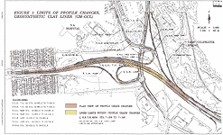
The redesign effects about 1250 meters of highway
62, of which about 350 meters will be lined.
See the map below.

Click
on map to view larger 167k image
The road was raised, but still had to be below the overflight rights of the airport, below the LRT bridge (which must be below the airport overflight), and below the highway 55 bridge (which has to be below the LRT bridge). One of the major aspects to do this, is a retaining wall down the center of Hwy 62 that allows each lane its own individual banking. That way one set of lanes doesn't need to be much lower than the oncoming lanes.
Where the road does go below the water table, it
will be lined. Because it is above the bedrock and not as deep as the
original design, a great amount of water pressure that will be against
the road is reduced, and that leads to a cheaper flexible liner (as opposed
to the old concrete liner idea). This helps out Coldwater Spring a-lot,
by staying away from the bedrock features it depends on, as well as allowing
water to flow below and around the liner. The liner itself consists of
multiple layers. There is really two liners that separate the road from
the groundwater and both would have to fail at the same place for a real
leak. The layers also allows for an equalization of water pressure across
the road as well. The liner is expected to outlast the surface of the
road. MnDOT is however, responsible for maintenance of the road and subsequent
liner.
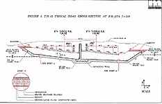
See the cross section below.

Click
on map to view larger 36k image
You will notice that the water table is below the liner. The majority
of the road will be this way, however it does become equal to the water
table at it's deepest. Of course that brings on the question of what is
the water table height, as it does change seasonally. The water level
agreed to was the July 31, 2002 levels. Because of the wet summer, they
are slightly above the seasonally high preconstruction levels of June
14, 2000, but not much.
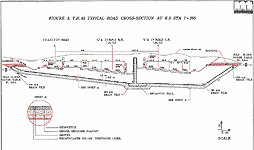
In the cross section below is one of the deepest parts of the road.

Click
on map to view larger 41k image
You will notice that if the water gets any higher, it will spill over the liner and into the drains. What this essentially means is that the redesign will have a negligible effect on groundwater in normal to slightly high water levels. It will not hold a flood or heavy rain levels. SO.....
The drains under the road in Low to Normal groundwater levels, will have
a discharge rate of ZERO!
Seasonally high groundwater levels, in rainy times (like this summer) the discharge rate is estimated to be 10.4 gallons per minute (at the intersection, not the spring).
A quick comparison to the connection of the interchange
and the Spring, MnDOT had to initially pump water at a rate of 225 gallons
a minute, then sustain pumping at 90 gallons a minute at the interchange
for months to produce the drastic draw down at Coldwater Spring.
The 10.4 gallons per minute dewatering with the redesign will only take place at wet times, and it's effect on Coldwater is expected to be undetectable with current measuring methods, according to watershed engineers.
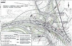
Below for reference, is the water table contours of the area, in both
the preconstruction levels and current levels.

Click
on map to view larger 146k image
THANKS to the GREAT effort of MANY, what once
looked to be the bleak destruction of Coldwater Spring, has become a compromise
that holds the promise of saving this resource for future generations!
THANK YOU ALL!!!
(The final plans will still be reviewed by the watershed districts,
to be sure all the concepts are adhered to, before construction
begins next spring.)