MnDOT's position now seems to be it's the MAC's (Metropolitan Airports Commission) fault for the recent decrease in flow from Coldwater Spring.
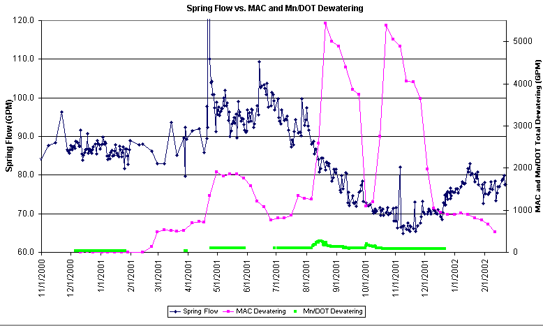
This graph shows the Spring flows in blue, and the amount of dewatering in green and pink. With MAC dewatering (pink) that is quite high (in the thousands of gallons a minute) and MnDOT dewatering (green) relatively low, and that Coldwater Spring flow lowers with the high amount of dewatering. MnDOT says their dewatering is too low to affect the Spring, and another outside influence is needed.
Looks like a good case. However one must also look at MnDOT's other positions. First, they say their own study that shows the recharge area for the Spring coming partly from the Hwy 55/62 interchange is wrong, as the water for the Spring, according to MnDOT comes from the NORTH, not the south. Therefore their interchange can't affect the Spring.
But when MnDOT dewaters the interchange, and the Spring flow rate decreases, despite higher precipitation, airport dewatering further SOUTH suddenly becomes part of the aquifer that feeds the Spring.
If that's not odd enough, recall that MAC agreed to line their tunnels with a coffer dam to isolate it from the surrounding groundwater.
Further, one must also include MnDOT positioning in their April 19, 1999 memo, that says the aquifer for the Coldwater Spring goes all the way to Lake Minnetonka. That's hundreds of square miles! You don't need to be a hydrologist to know that if the aquifer is that large you end up with a lot more water than the hundred gallons a minute that can flow out of Coldwater Spring. But MnDOT says this aquifer includes other discharge areas along the west bank of the Mississippi river too. Therefore MnDOT dewatering isn't large enough to affect the flow to the Spring.
The Minnehaha
creek Watershed district's position is that a much smaller area is the
recharge area for the Coldwater Spring. This partly includes the Hwy55/62
interchange area (concurring with the
MnDOT study) that is only 400 yards away. "Between July and November
2001 -- during continuous [MnDOT] pumping -- CCS flow diminished by more
than 30 percent, regardless of whether the MCWD's or MnDOT's own flow
data are used -- and regardless of changes in rainfall patterns."
But Bob Winter, MnDOT's metro division engineer, said the study has reached the wrong conclusion. "We think there's additional data available that indicates water levels throughout the district -- including way upstream -- are showing the same fluctuations," Winter said. "We think a lot of what they're reporting is natural seasonal variations."
MnDOT has an answer for everything....way up stream can be North, or South, it goes all the way to Lake Minnetonka to the West, and if the Spring flows lower than it ever has in recorded flow rates, maybe it's natural "seasonal" variations, because it absolutely no matter what, can't be MnDOT dewatering 400 yards away that affects the Spring.
What happens
now?
The Federal Highway Administration will likely require further
testing to verify which position is right.